
ADVERTISER DISCLOSURE: The Frugal Tourist is part of an affiliate sales network and receives compensation for sending traffic to partner sites, such as MileValue.com. This compensation may impact how and where links appear on this site. This site does not include all financial companies or all available financial offers. Terms apply to American Express benefits and offers. Enrollment may be required for select American Express benefits and offers. Visit americanexpress.com to learn more. All information about the American Express Schwab Platinum has been collected independently by The Frugal Tourist.
EDITORIAL DISCLOSURE: Opinions, reviews, analyses & recommendations are the author’s alone and have not been reviewed, endorsed, or approved by any of these entities.
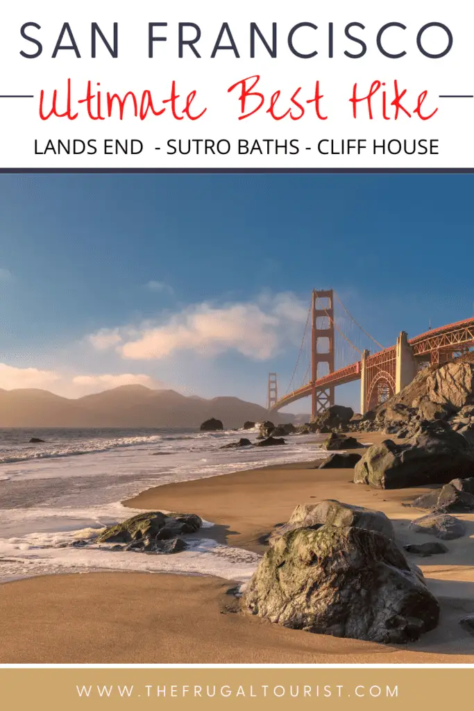
Lands End is hands down the ultimate urban hike in San Francisco and one of the best hikes I have ever done in a metropolitan city.
In fact, I’ve embarked on countless walking tours and city hikes in my travels, and I have yet to come across an urban trail that overshadows Lands End.
Do you only have time for one hike while in San Francisco? This is IT.
Are you in SF only for a few days?
If so, devote some time to visiting. You will not regret it.
If you are a local and have not walked along these trails, plan to do so soon.
Even after hiking here so many times, the views never fail to amaze me.

SF’s Best Urban Hike
By and large, this trail seems to have it all — fascinating history, astonishing ruins, splendid Golden Gate Bridge views, and the opportunity to touch the mighty Pacific Ocean.
And that’s only the tip of the iceberg.
Prepare a snack and a blanket, as we will visit three beaches if the tide permits.
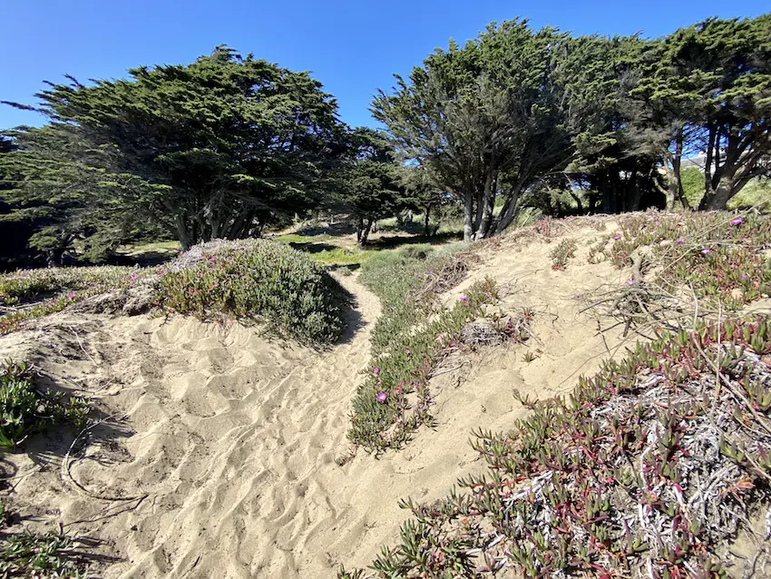
There are also sand dunes, a popular labyrinth, and a stunning secret stairway.
When we return to our trailhead, we will take a different route so we can pay respects to two poignant monuments – a touching Holocaust memorial and a tribute to the people who perished on a Second World War Warship, named after the city.
Additionally, if the stars align, you might even see remnants of shipwrecks, frolicking whales & dolphins, and boisterous sea lions.
Without further ado, let’s dive in.

HEADS UP: Make sure to time your visit when the coast is clear. Should fog be present, don’t fret; be flexible and modify plans accordingly. This trail will be somewhat of a disappointment without the sweeping views. I have a few alternative recommended tours in this blog that are about just 10-15 minutes away. You can access them here.
Free Downloadable Walking Tour Maps
I’ll be sharing two maps that you can quickly download to your smartphone.
The first map shows my recommended path to the end of the hike, the Lincoln Park Steps.
The second map is a different trail that will take us back to our trailhead.
Total Distance: 5 miles (2-3 hours)
Part 1: Sutro Heights, Sutro Baths & Lands End
Part 1: Downloadable Map
Star this map, and it will automatically download on your Google Maps app. You can also forward the map to anyone who might be interested.
Part 1 Total Distance: 3 miles
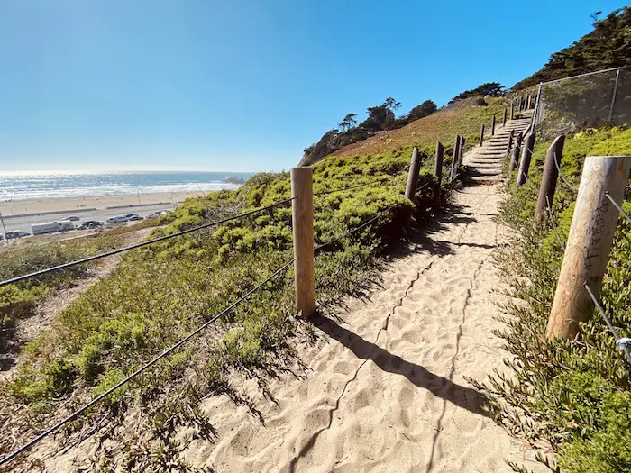
A. Start: Sand Stairway to Sutro Heights Park
Park anywhere in the vicinity of Balboa and La Playa Streets.
You are now in the Richmond District, the westernmost edge of San Francisco, which intersects with the Pacific Ocean.
If you are driving, make sure all valuables are hidden and safely locked in your trunk.
This area is one of the most popular stomping grounds for burglars in SF.

Previously, this entire area was covered by sand dunes for miles.
Dubbed “The Outside Lands” by locals, it was historically inaccessible and uninhabitable.
The video below, by local Joey Yee, offers a brilliant introduction to one of San Francisco’s most beautiful corners.
For our start point, I picked the sand stairway erected on these sand dunes as a fitting tribute to SF’s past.
These steps, located near the corner of Balboa & La Playa, will ultimately deliver you to the former estate of Adolph Sutro.

B. Sutro Heights Park
At the top of the sand stairway is a pathway that leads to Sutro Heights Park.
The views of the Pacific Ocean on this trail are spellbinding, so remember to look to your left and walk slowly to enjoy the breeze and the phenomenal vistas.
Unreachable and remote for centuries, only one person dared to explore and invest in this desolate part of the city, and that person was Mr. Adolph Sutro.
Who is Adolph Sutro?
Adolph Sutro was a German immigrant who became the mayor of San Francisco from 1895 to 1897.
He invested in several properties in San Francisco, including Lands End, the Sutro Baths, the Cliff House, and Sutro Heights Park, the former site of his enormous estate.
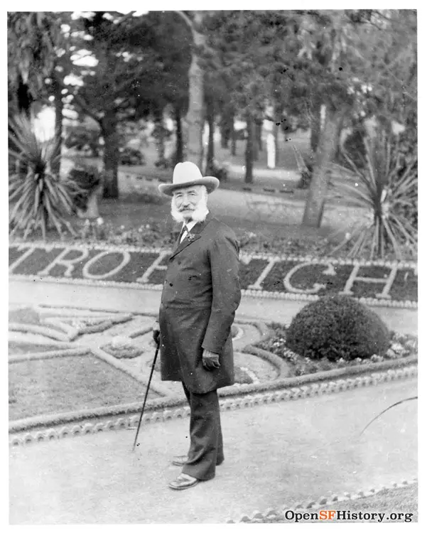
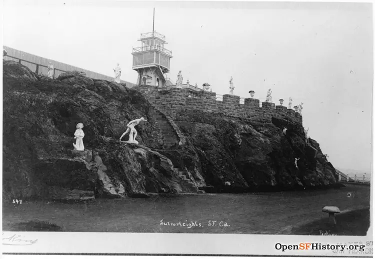
Sutro’s Estate
Constructed in 1881, Mr. Sutro’s modest mansion – perched atop this bluff and surrounded by sand dunes – was speckled with over 200 chiseled Greek statues, gorgeous gardens, an observatory, and an elaborate greenhouse that featured rare orchids and exotic plants.
Another video below of SF local Joey Yee takes a trip back in memory lane to reminisce about how Sutro Heights and the surrounding areas looked when Mr. Sutro was still alive.
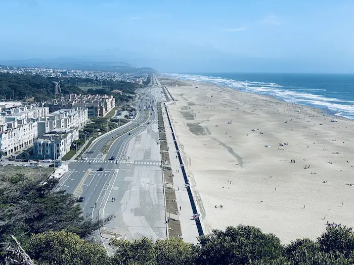
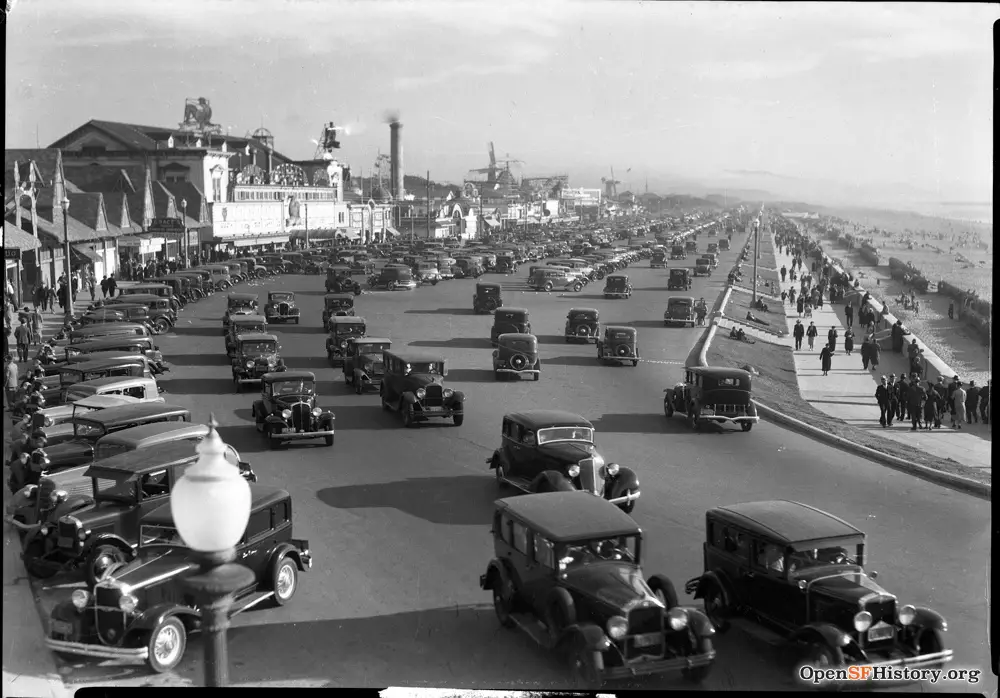
Ocean Beach View
Panoramic views of Ocean Beach and the Pacific Ocean are unbeatable from Sutro Heights Park.
Spot the Great Highway, the road that runs between the beach and the city, and compare it to how it was back in the 1930s.
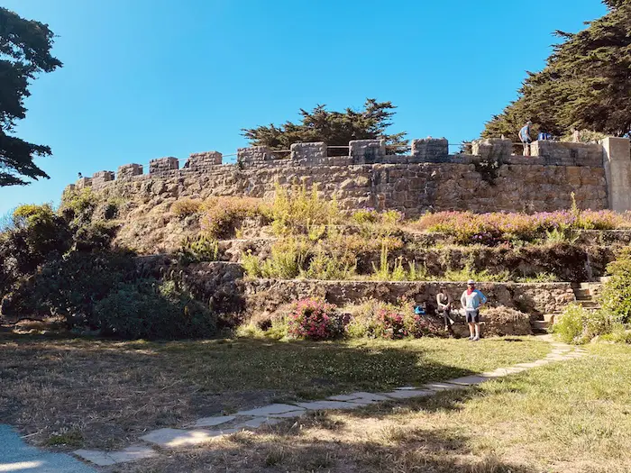
Stone Parapet
Standing firm as the only remaining testament of the immense Sutro Estate was the Stone Parapet.
Go climb up a few steps, as the additional altitude will reveal more breathtaking views.
Actually, there are two surviving remnants from Sutro’s estate.
A statue of the Greek Goddess Diana has also survived the test of time and is still lurking around the grounds.
Try to find her!
Lion Statues
Since we entered Sutro Heights Park from the back door, we will exit the estate through its former elegant front entrance gate flanked by lion statues.
The gate has succumbed to decay, but evocative replicas of the lions still remain to remind us of the estate’s grandiose past.
Mr. Sutro lived here until his death in 1898.
His family took on the management of his properties and continued to reside here until Mr. Sutro’s daughter passed away in 1938.

This sprawling estate was eventually donated to the city, and the structures were demolished during the Great Depression.
With a bit of help from their imagination, anyone can easily visualize how lavish this place was during Sutro’s time.
Thankfully, pictures are also plentiful online.
Currently, this park provides a welcome refuge for tourists and locals alike who desire a leisurely stroll or picnic while offering quick access to stunning ocean views.

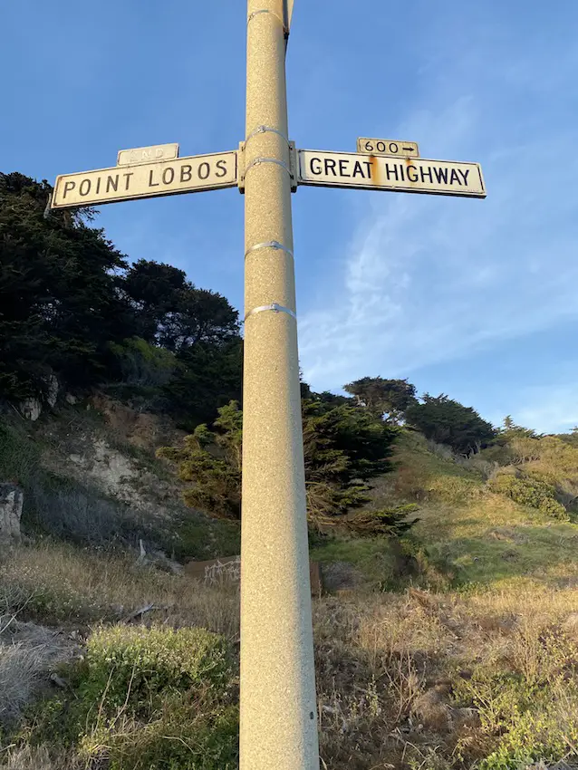
Exit the park at this once grand entrance and head out to the corner of 48th Avenue & Point Lobos, a few steps away.
C. Point Lobos Avenue & 48th Avenue for Lands End Trailhead

At this corner, safely cross the street to the opposite side to find the Lands End Trailhead, which is a segment of the extraordinary Coastal Trail.
We are now entering the Sutro District of the Golden Gate National Park.

But before you embark toward Lands End, we are going to make an important detour in the arresting ruins of Sutro Baths, which is about 0.4 miles from this corner.
Just follow the signs.

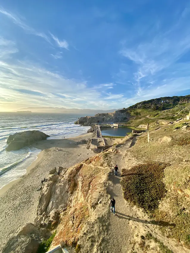
D. Sutro Baths Ruins & Cave
Locate the sand stairway leading to the ruins of Sutro Baths.
Descend the stairs slowly and pretend to be one of the excited locals waiting for their turn to access this humongous public bath situated next to the Pacific Ocean.
Sutro’s chosen location for these pools couldn’t have been more spectacular.
Passionate about the untapped potential of his newly acquired properties, Mr. Sutro built this herculean public bath just below his colossal estate in Sutro Heights Park, where we just came from.
These baths were just one of the many gifts Mr. Sutro bestowed on the residents of San Francisco during his tenure.

The Baths for Every San Franciscan
Generous to a fault, Mr. Sutro wanted everyone, regardless of income, to have access to the baths.
Unfortunately, he faced a significant obstacle — the baths’ remote location.

Reaching the baths posed a significant challenge as locals had to endure hours just to traverse the undulating sand dunes in Outside Lands.
Undeterred by this sandy barrier, Mr. Sutro funded the construction of a public steam railway that rapidly transported city residents to his gigantic indoor waterpark.
Anyone in SF could finally access and soak in Sutro’s ambitious project.

Popularity skyrocketed, principally driven by the baths’ low entry fees.
Likewise, the round-trip train tickets were also priced substantially low, ensuring that the pools would never run empty.
Its 7 pools are meant to serve up to 10,000 SF of residents at any given time.

Patrons could bathe in saltwater or springwater pools with varying temperatures.
Entertainment was provided, and a museum featured Sutro’s extensive collection of artifacts he had brought home from his travels.
An excursion here was truly an experience to remember for many local San Franciscans at the time.
Watch the video below of the 1902 rail journey through Land’s End.
I could only imagine how exhilarating the trip was back then.
Tragically, the Sutro Baths were engulfed by flames in 1966 and never reopened.
What remained for you to see were the atmospheric ruins of its foundations—a haunting memento of its magnificent past.
The video below reminisces about the glory days of the Sutro Baths, once the world’s largest public baths.
Cave
After exploring what remains of the Sutro Baths, locate the cave, which will be on your right as you face the Pacific.
Feel free to enter and walk to the end for a wondrous symphony of ocean waves crashing against massive rocks.
It can be slippery, so watch your step.
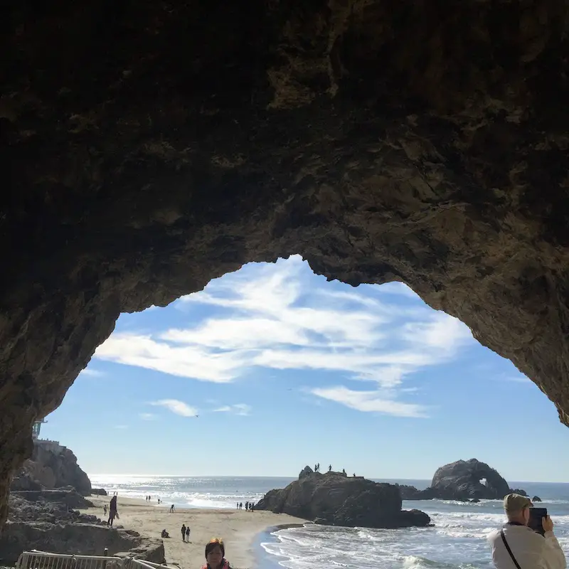
Exit the cave and walk towards the beach.
Before you leave this area for our next stop, you are more than welcome to unfurl your blanket here.
Find a spot near the gigantic rocks called Seal Rocks, where sea lions used to congregate.
Or you can skip this beach and wait for the next one—the more scenic Mile Rock Beach—about half an hour away.
E. Sutro Baths Upper Trail for Point Lobos Lookout
After exploring the ruins, head back to where you came from.
However, instead of going all the way back up to the top of the same stairway, veer to your left on a path that will lead to another viewpoint located just above the cave we just visited.
Or, just follow the red line on the image below.
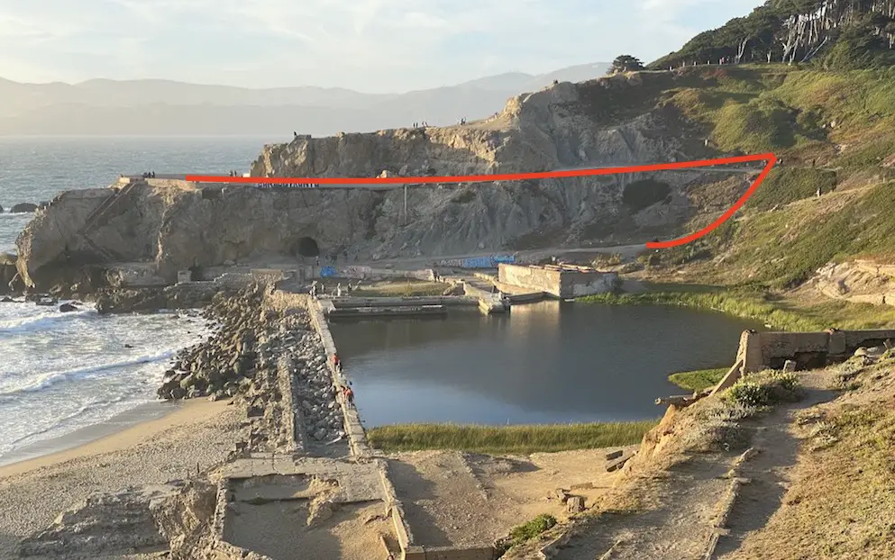
This is the Sutro Baths Upper Trail & Point Lobos Lookout.
From this vantage point, you can prepare for a stellar bird’ s-eye view of the Sutro Bath ruins.
The Cliff House, the white building on the other end (see image below), and one of the stops later on this hike are also visible from here.
After being blown away by this vista (literally and figuratively), continue walking away from the ocean and the baths.
Follow the trail until you emerge on the other side of the Upper Trail (see image below).
This is where we reunite with the Coastal Trail.
Make a left and continue to our next point – the Eastern Coastal Trail Overlook.
F. Eastern Coastal Trail Overlook
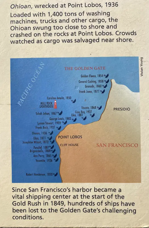
A notable viewpoint along this trail, the Eastern Coastal Trail Overlook offers insights into the numerous shipwrecks that met their fate in this part of the Pacific Ocean, which was known as one of the most perilous locations in the late 1800s.
Rest here for a few minutes and savor the fabulous views of the Pacific Ocean and the Golden Gate Bridge.
When you are ready, continue your trek down Coastal Trail until you reach a stairway.
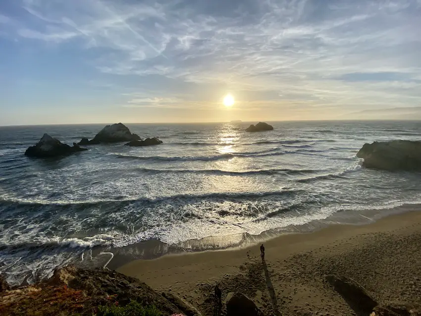
G. Mile Rock Beach
The next stop is another highlight—the amazing Mile Rock Beach.
Continue down the trail until you find the stairs on your left that lead to this unforgettable beach.

Descend the stairs all the way until you reach the Pacific Ocean.
This section of the coast is incredibly gorgeous, and if the weather permits, you can roll out your beach blanket and take in the impeccable scenery.
Occasionally, whales and dolphins can be seen swimming around here.
Try to spot the Mile Rock Lighthouse a bit farther away.
If you’re lucky and if it’s low tide, some shipwrecks might reappear as well.

Once you’ve been wholly rejuvenated, start packing up and head back to where you came from.
Instead of taking the stairs back up again, stop and look for an unmaintained narrow path that veers to your left.
Follow this trail, as it will take us to our next stop—the famous Land’s End Labyrinth.
Watch your step, though; this “secret” pathway may be vulnerable to erosion at any time.
If you are terrified, there are other entry points to access the labyrinth as you climb back up the stairs towards the main trail.
Or, just ask around, as other hikers will undoubtedly be more than happy to point you in the right direction.
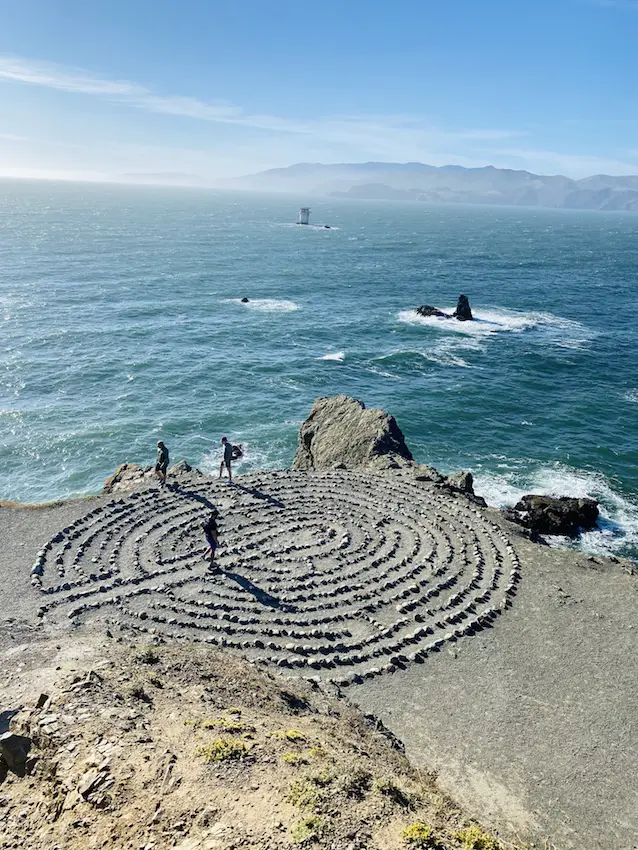
H. Lands End’s Labyrinth
Once at the labyrinth, congratulate yourself on making it to this special place.
The unobstructed views of the Golden Gate Bridge from this awe-inspiring spot are beyond compare.

San Francisco artist Eduardo Aguilera was first inspired by learning about other historic labyrinths, and then moved to create his own after spending time along the rocky shoreline of Lands End, lighting candles and creating a small shrine to, in the artist’s own words, “peace, love and enlightenment.” Aguilera’s creation is constructed simply of a stone outline following the classic seven-circuit Chartres labyrinth. At first he hoped to keep it anonymous but his work was quickly discovered by other hikers and explorers. The labyrinth has been destroyed on two occasions by persons unknown, but Aguilera rebuilt it each time. In 2004 the artist lit the labyrinth with candles for the Winter Solstice, and in 2005 he lit it ablaze for the Vernal Equinox. One of the last incidents happened in 2015 when the Labyrinth was destroyed yet again. However, a month later the author with a team of volunteers restored the design.
Atlas Obscura
It is possible to walk towards the middle of the labyrinth.
Tourists and locals alike have left random objects here as offerings to the universe.

Around the corner, there is an unmarked path that will take you to the top of another small bluff for a bird’s-eye view of the labyrinth (see image below).
While the view is a sight to behold, the trail does require some scrambling, so be careful, or skip it if you are uncertain about your footing.
From the labyrinth, there are a few paths that connect to the Mile Rock Beach Stairway that will take you back up to the Coastal Trail.
I. Eagle’s Point Overlook
At the top of the stairway, reconnect with the Coastal Trail and turn left.
Continue on the trail until you reach Eagle’s Point Overlook, located at the opposite end of Land’s End.

Stupendous views of the Golden Gate Bridge await exhausted hikers at this viewpoint.
Take a break here and relish the moment, you’re almost at the end of Part 1 of this astounding urban hike.
Once you’re ready, continue your trek all the way to the end of this trail, which will terminate at Lincoln Highway.

Look for the Land’s End sign at the end of this trail and take a picture of yourself with it as a souvenir for completing one of the most entrancing city walks anywhere.

Now, exit Land’s End for a moment and cross Lincoln Highway to the other side.
The green section before you is part of the Lincoln Park Golf Course.
Follow the path on the map below to reach our Part 1 finale, the Lincoln Park Stairs.
The trail is parallel to the straight black line I drew on the map, tucked between the golf course and the Katherine Delmar Burke School.
This is a relatively unpopular path so you might be the only one here when you visit.
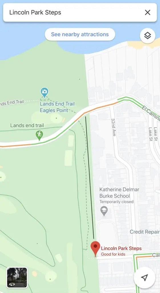
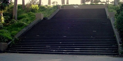
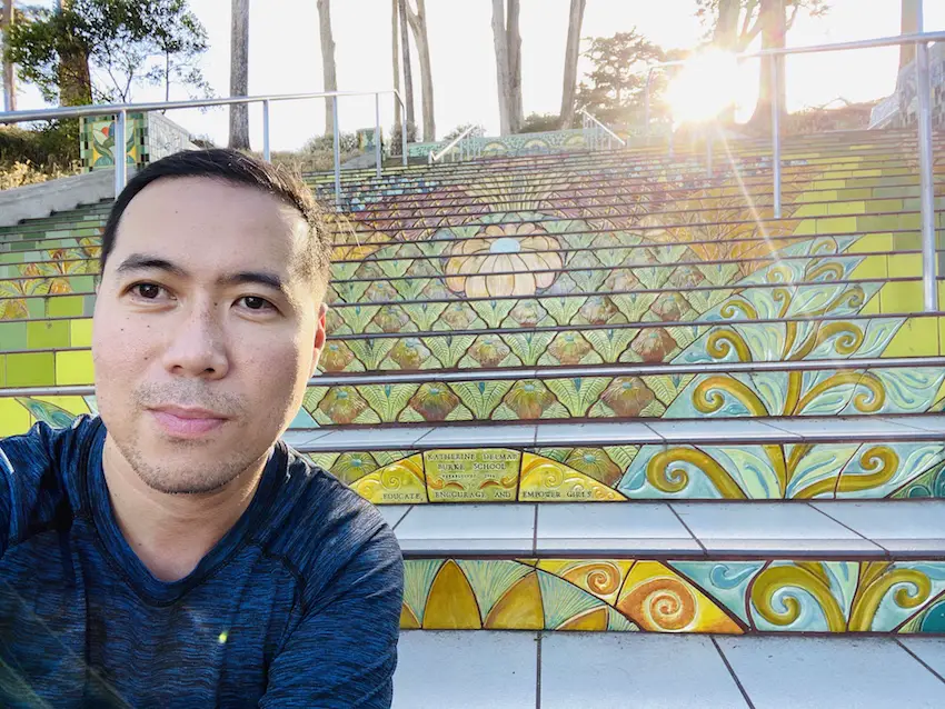
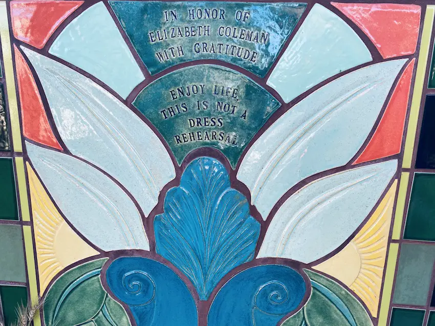
J. Lincoln Park Steps
Walk along the hidden pathway (see map above) until you reach the top of the Lincoln Park Steps.
Descend the stairs and look back when you get to the bottom.
What a delightful surprise!
If you were like me, you would have been awestruck at first glance, too.
Bonus points if you time your arrival an hour or two before sunset.
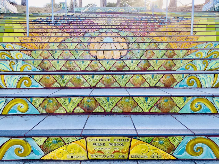
The stairs are a masterpiece and the thrilling finish line to the first part of this hike.
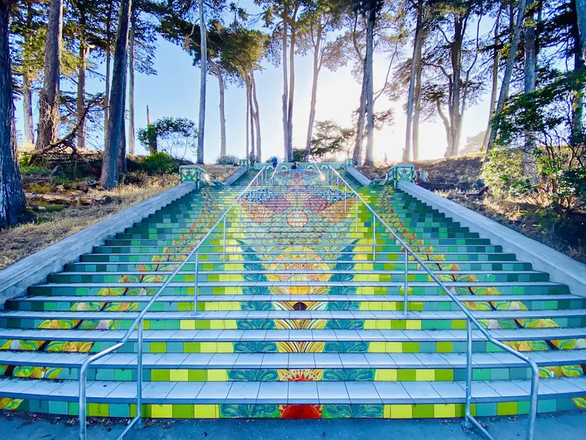
Sit down on one of the benches and check out the names of the artists and donors inscribed on some of the tiles.
Pat yourself on the back for finishing Part 1 of this hike.
When you are ready, we will embark on Part 2 of this walking tour.
If you are extremely exhausted, you can take Uber/Lyft back to where we started.

Part 2: Lincoln Park Steps, The Memorials, Cliff House & Ocean Beach
Part 2: Downloadable Map
Star this map, and it will automatically download on your Google Maps app.
Feel free to share it with anyone who might be interested.
Part 2 Total Distance: 2 miles
A. Lincoln Park Steps
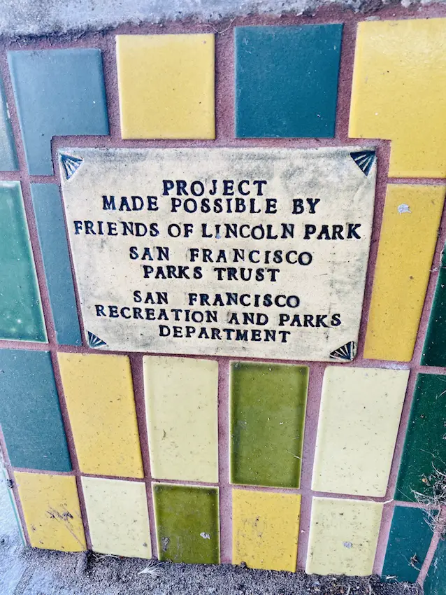
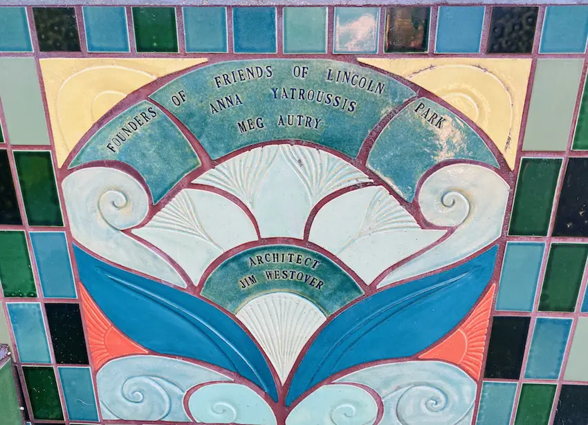
The Lincoln Park Steps sit at the edge of Lincoln Park on the Western end of California Street and date back to the early 1900’s. In 2007, Friends of Lincoln Park founders, Anna Yatroussis and Meg Autry, had the vision for a complete design and structural renovation of the Lincoln Park steps, an iconic staircase that had seen decades of neglect and decay.
www.lincolnparksteps.org
From the Lincoln Park Steps, retrace your steps back towards Land’s End.
Instead of taking the Coastal Trail from Part 1, we will walk along Lincoln Highway to our next stop, the poignant Holocaust Memorial.
B. Holocaust Memorial
Created by artist George Segal in 1984, this haunting memorial of the horrors of the Holocaust is one of the most emotionally impactful stops in this urban hike.
Eleven figures represent Jews in concentration camps, with all but one lone survivor, still held captive, clinging to a barbed wire fence.
Despite their white appearance, these sculptures were actually chiseled from bronze, covered with white paint to resemble plaster.
It was given to the city of San Francisco as a gift by Segal.
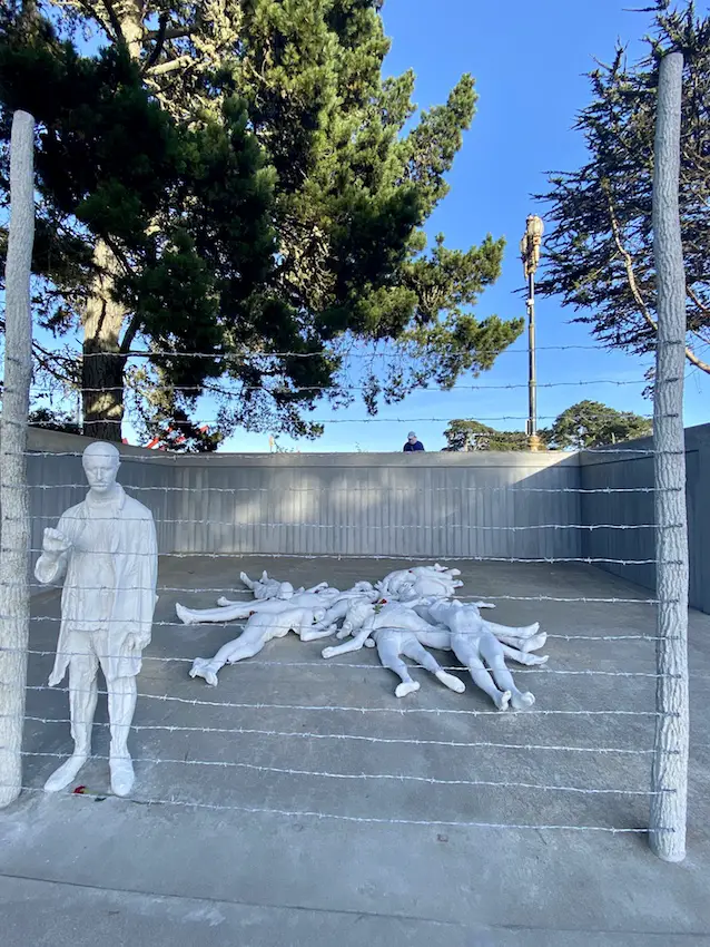
Several of the bodies in the sculpture were designed to be symbolic. One of the bodies resembles Christ, another is of a woman holding an apple, evoking Eve. Both symbolize the connection between Jews and Christians. The only standing man, a survivor, is thought to be the sculptor’s representation of Margaret Bourke-White‘s famous Life Magazine 1945 photograph of the liberation of Buchenwald.[2] Segal’s friends posed for the casts, so they are not emaciated like the corpses found at the liberation of Buchenwald. This was an intentional choice by the artist, as was the star formation of the corpses, which added some order to the chaotic helter-skelter of the corpses in the liberated concentration camps.
Wikipedia

Over the years, these figures have repeatedly endured vandalism, the most common of which were graffitis of swastikas drawn on the bodies.
Watch the video below about the restoration project completed in 2019.
After paying respects to this touching memorial, you can explore the grounds of the Legion of Honor Museum, located right next door, or enter to check the exhibit for a small fee.
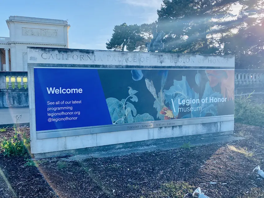
C. Legion of Honor Museum
Dubbed one of the most beautiful museums in San Francisco, the Legion of Honor Museum’s enviable location offers views of the Pacific Ocean and the Golden Gate Bridge right outside its doors.
Boasting an impressive collection of European Paintings, Decorative Arts, and European sculptures, this is a worthwhile stop if you have the luxury of extra time.
Rodin’s “The Thinker” graces the museum’s central court and is its biggest draw.

This French Neoclassical building was given to the city as a gift from Alma de Bretteville Spreckels.
More about the history of this building can be found here.
A modern orange sculpture, Pax Jerusalem, by Di Suvero, was erected in front of the Legion of Honor.

Once done exploring the grounds outside or the museum’s collections, it is time to reconnect with the Coastal Trail, located nearby (refer to the Google Maps above).
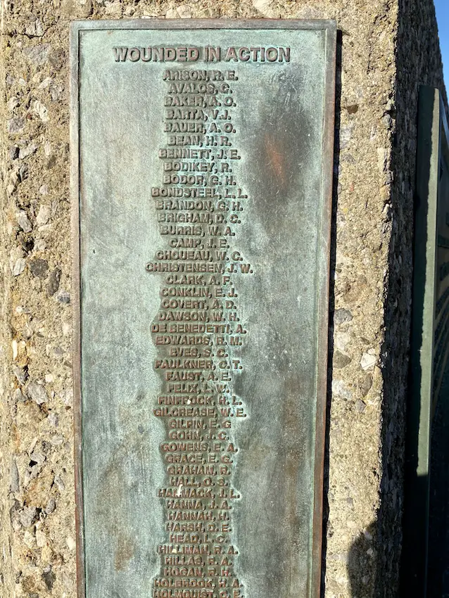
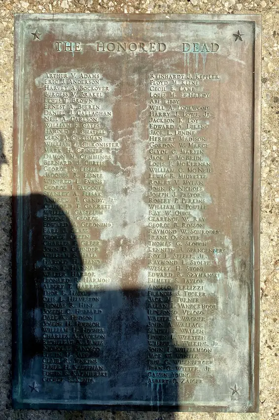
Our next stop is another memorial, this time a World War II warship named after the city. Just follow the arrows to the USS San Francisco Memorial.
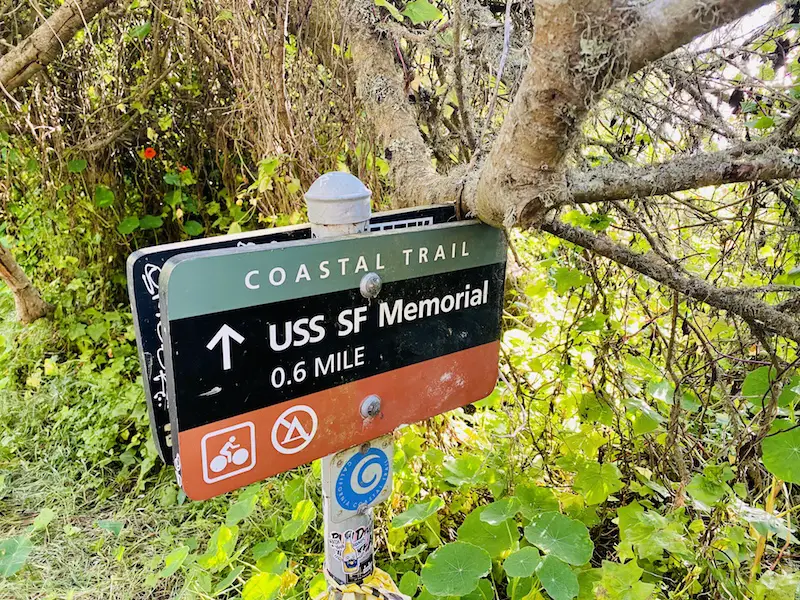
D. USS San Francisco Memorial
This heartfelt memorial dedicated to the men who perished and were wounded aboard the USS San Francisco during the Second World War is another somber stop in this urban hike.
During my visit, I met relatives and family members of people who died while stationed on this ship serving our country.
If you would like to read more about its history, click here.

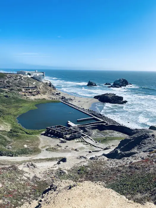
E. Lands End Lookout Visitor Center
You have a few options for connecting the USS San Francisco Memorial to the Land’s End Lookout.
Should you prefer a more scenic route, you can continue along the “lower” Coastal Trail, which is similar to the path we took in Part 1 of this walking tour.
Alternatively, you can continue along the “upper” Land’s End Trail, which will also take you to our next destination in about the same time.
Feel free to refer to the map I provided to compare both paths.
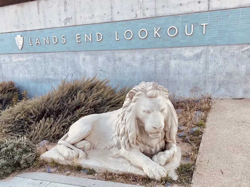
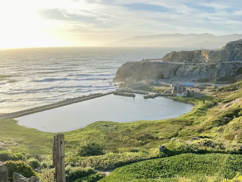
Lands End Lookout has a few trails that also connect to the Sutro Bath ruins, providing a different perspective of the baths.
Some paths are unmarked and unstable, so please watch your step.
Below is an image of the ruins slightly before sunset, captured from the Lookout.
F. Cliff House
Dramatically perched atop a cliff facing the majestic Pacific Ocean, with enigmatic sunsets and staggering views, the Cliff House has been a popular tourist destination in San Francisco for over a century.
After several iterations over the past century, its irresistible charm continues to seduce tourists to this location, making it one of the most visited attractions in the city.
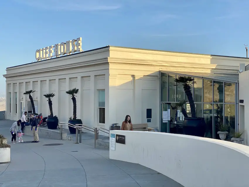
Although no longer as grandiose compared to its previous selves, the views from the Cliff House terrace are still guaranteed to blow you away.
Time your visit at sunset and when the fog is not around.
Four different Cliff Houses have been constructed in this exact spot, and the second version, an opulent 7-story Victorian Chateau from 1896, wins as my personal favorite.
An in-depth history of the various Cliff Houses is also available here.
In 1896, Adolph Sutro built a new Cliff House, a seven-story Victorian Chateau, called by some “the Gingerbread Palace,” below his estate on the bluffs of Sutro Heights. This was the same year work began on the famous Sutro Baths, which included six of the largest indoor swimming pools north of the restaurant that included a museum, ice skating rink and other pleasure grounds. Great throngs of San Franciscans arrived on steam trains, bicycles, carts and horse wagons on Sunday excursions.
Wikipedia

Multiple viewing platforms and an expansive terrace welcome tourists eager to capture that picture-perfect shot of the Pacific coastline.
On a clear day, the North Observation Deck and the back terrace reward tourists with views that extend to the Farallon Islands.
On the south side of the Cliff House Terrace is our next destination, the Camera Obscura & Holograph Gallery, and an impressive view of Ocean Beach.
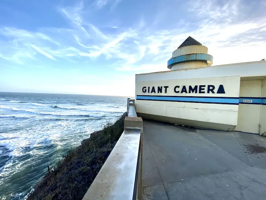
G. Camera Obscura & Holograph Gallery
This tiny museum packs a powerful punch by offering an opportunity to use an operational camera obscura to capture 360-degree live images of the San Francisco Bay.
The 4-minute video below describes how it works.
Built in the 1940s by Floyd Jennings, this camera was initially one of the primary attractions at the Playland at the Beach Amusement Park, previously located near Ocean Beach.
Check it out if it’s open.
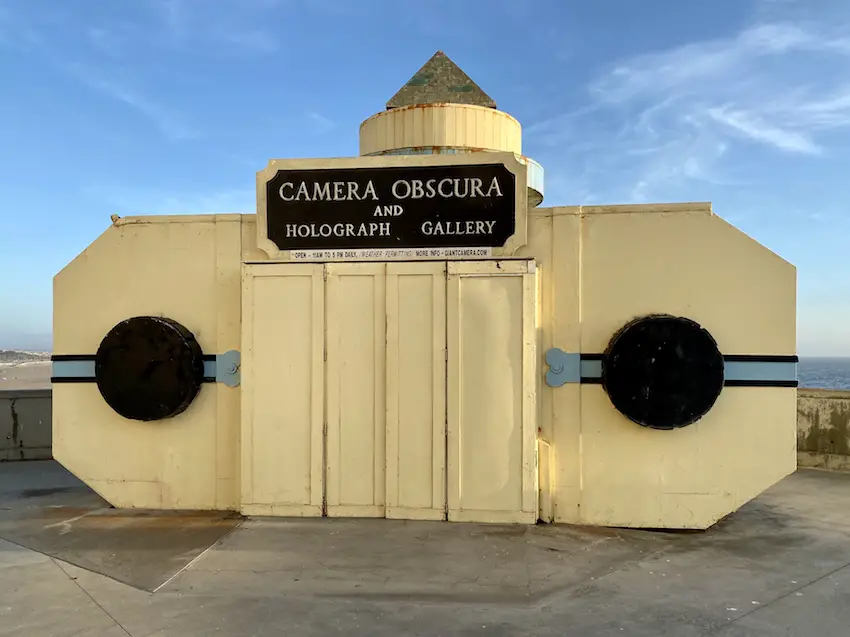
The Camera was nearly shut down twice: once following the closing of Playland at the Beach in the 1970s and again in 1999 when the Cliff House was renovated. Public support has kept it open, and in 2001 it was added to the National Register of Historic Places and saved from destruction.
Atlas Obscura
We are almost at the end of our urban hike.
Our next stop is Ocean Beach, just below the Cliff House.
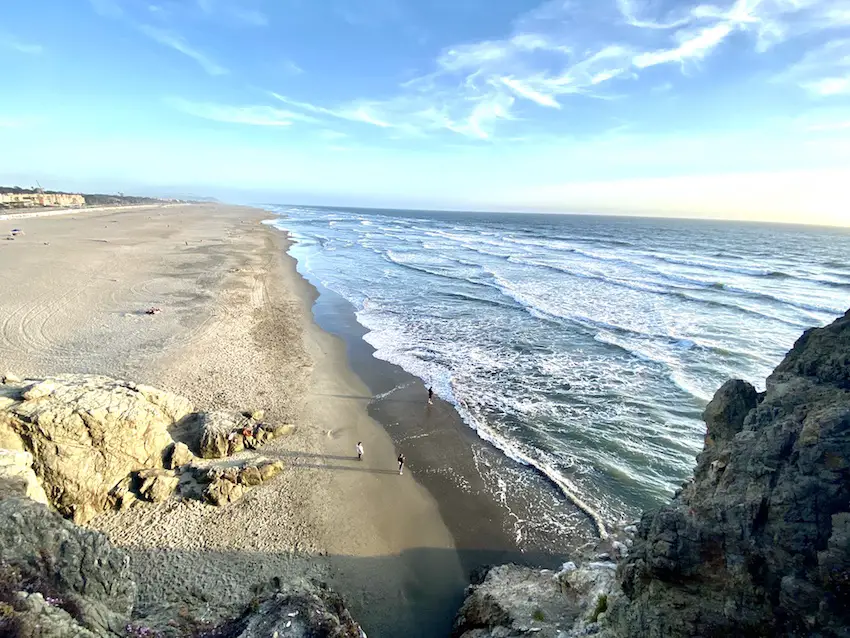
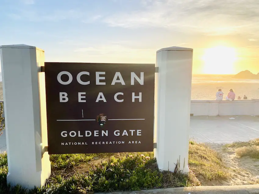
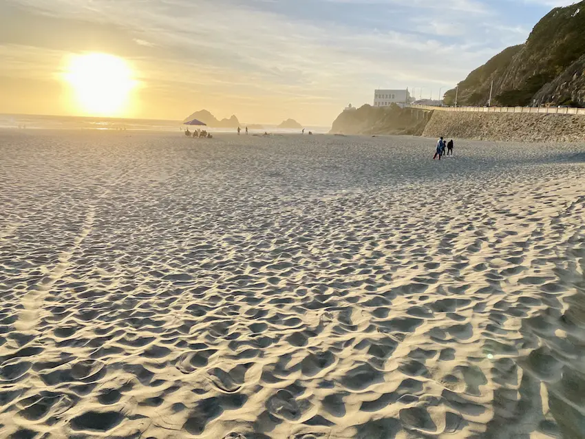
H. Ocean Beach
Previously inaccessible to city residents because of the immense sand dunes covering much of San Francisco’s western neighborhoods, Ocean Beach owes its claim to fame to Mr. Sutro.
The Sutro Baths and Cliff House, built in the northernmost section of the beach, made Ocean Beach a household name.
We are visiting this exact section, which is also the most expansive, scenic, and popular stretch of SF’s Pacific Coastline.
On a warm day, beachgoers, locals, surfers, and tourists converge in this stunning part of SF.
The best months to walk the entire 3.5-mile stretch are late summer and early fall.
Sunsets here are bewitching, so try to plan to finish this urban hike around that time.
If it’s low tide, you might even see shipwrecks.
Shipwrecks in the Sand
https://www.parksconservancy.org/parks/ocean-beach
At the foot of Ortega Street during very low tides, you can see the worn ribs of the hull of the ship King Philip sticking out of the sand. Between 1850 and 1926, 20 ships came to grief on Ocean Beach.

I. Sutro Sand Dunes at Balboa Natural Area
Safely cross the Great Highway towards our final stop—the only remaining section of the sand dunes from Outside Lands.
Isn’t it fascinating to ponder that the entire Western San Francisco was blanketed by sand dunes in the past?
The Balboa Natural Area is a small, 1.8-acre site at the corner of Balboa Street and the Great Highway in western San Francisco. This Natural Area is located in the southern corner of the Sutro Heights Park and across the Great Highway from Ocean Beach and the Pacific Ocean. Because the site is entirely sand, public access is provided via an elevated boardwalk that helps to keep people out of the sensitive dune vegetation.
sfrecpark.org
We are ending this hike at this spot because it underscores how incredibly beautiful SF was back then, even before it evolved into a metropolis.
It was just sand dunes, ocean, rocks, bluffs, hills, and Mr. Sutro, and this Lands End tour encapsulates it all.
That is why I am ranking this as the ultimate San Francisco urban hike!
J. Back to the Trailhead
From the Sutro Sand Dunes, retrace your steps back to where you parked your car near Balboa and La Playa Streets.
CONGRATULATIONS!
You have just walked 5 miles on some of the most picturesque trails in San Francisco and the entire planet.
Do you agree that this is San Francisco’s best urban hike?
Please feel free to leave a comment below if you were able to complete this trek and share your thoughts about our itinerary. We would love to hear your feedback.
If you would like to explore similar walking tours in San Francisco, I have a few favorite walks listed here.
Before your Trip to San Francisco
Where to Stay
San Francisco is expensive, even for locals.
For tourists, I suggest using credit card points and free night awards to save some cash.
I got this free stay at the Kimpton Alton in San Francisco’s Fisherman’s Wharf area from my IHG One Rewards Premier Business Credit Card.

I also recommend the Hyatt Centric Fisherman’s Wharf Hotel, which is located a minute away from the Kimpton.
I stayed here for free using the World of Hyatt points I earned from my Chase Sapphire Preferred® Card and World of Hyatt Business Credit Card.

Travel Insurance
How to FLY to San Francisco for almost FREE
All of my trips over the past decade had been ALMOST FREE via travel miles and points.
I accumulate these points from credit card rewards and bonuses.
Some of these credit cards are featured here.
If you are new to traveling using miles and points, join us in our Free Travel Miles and Points Facebook Group.

Final Thoughts
In conclusion, San Francisco’s Lands End is the ultimate urban hike for its diverse, breathtaking landscape.
From sandy dunes to historic ruins, stunning beaches to magnificent views of the Pacific Ocean and the Golden Gate Bridge, this hike offers a unique experience not found in any other city.
For tourists seeking a memorable adventure and a taste of nature in an urban setting, Lands End is highly recommended as an extra-day activity in their itinerary.
So lace up your hiking boots and explore the wonders of Lands End while in San Francisco.
ADVERTISER DISCLOSURE: The Frugal Tourist is part of an affiliate sales network and receives compensation for sending traffic to partner sites, such as MileValue.com. This compensation may impact how and where links appear on this site. This site does not include all financial companies or all available financial offers. Terms apply to American Express benefits and offers. Enrollment may be required for select American Express benefits and offers. Visit americanexpress.com to learn more. All information about the American Express Schwab Platinum has been collected independently by The Frugal Tourist.
EDITORIAL DISCLOSURE: Opinions, reviews, analyses & recommendations are the author’s alone and have not been reviewed, endorsed, or approved by any of these entities.
USER-GENERATED CONTENT DISCLOSURE: The comments section below is not provided or commissioned by the bank advertiser. Responses have not been reviewed, approved, or otherwise endorsed by the bank advertiser. It is not the bank advertiser’s responsibility to ensure all questions are answered.